|
Author
|
: Bill Kochman
|
|
Publish
|
: Jun. 7, 1998
|
|
Update
|
: Apr. 17, 2020
|
|
Parts
|
: 06
|
Synopsis:
Claim Of Zero Satellites Orbiting Over The Poles, Topography Of The Arctic, Hollow Earth Contradicts The Genesis Account, Physical Impossibility Of The Inner Ocean, High Quality NASA And NOAA Images That Refute Hollow Earth Theory, Questionable Images Used To Support Hollow Earth Theory, Deception Used By Some Hollow Earth Believers To Win Converts, Problem With No Light Shining From The Polar Holes, Protocol on Environmental Protection to the Antarctic Treaty, Hole In Ozone Layer Theory Charged Particles And The Magnetic Field, Wooly Mammoth Tusks Business, Genesis Flood: Frozen Carcases, God Drives Back The Waters By A Strong Wind, Rapidly-Thawing Permafrost In Siberia
Continuing our discussion from part two, another point worthy of mention, is that it has been claimed by certain proponents of the Hollow Earth Theory that it was discovered that due to the lack of any satellites orbiting over Antarctica, all the weather reports originate on the ground from McMurdo Station itself. Hollow Earth theorists conclude that this is a direct step taken by the Americans to prevent the release of any satellite images of the South Pole which might reveal the polar opening into the Inner Earth. However, as you will see momentarily, the idea that the US government doesn't have any satellites capturing images of the two poles is utterly bogus. Not only that, but these images have been released to the public for educational purposes as well.
I do remember that this particular point did in fact pique my curiosity when I wrote the original version of this series back in June of 1998. So much so that I scoured the Internet looking for photographs which clearly show the polar regions. I don't recall now if I ever found any. However, just now as I was in the process of updating this series twenty-two years later, I conducted a brand new search. What I discovered is the following information which casts rather serious doubt on the claims supposedly made by Admiral Richard E. Byrd in his purported secret diary.
As it turns out, unlike the South Pole which sits on a huge land mass -- that is, Antarctica -- which boasts an average elevation of about 7,500 feet, the North Pole is situated in the middle of the Arctic Ocean, surrounded by waters which until recent decades, were almost permanently covered with sea ice. Depending on the weather and climate, this layer or sheet of Arctic ice is anywhere from two to three meters in thickness, or about six feet seven inches to nine feet and ten inches in thickness. This vast field of sea ice averages about one foot above sea level, and expands and shrinks each year during the changing of the seasons. As you may know, in more recent years, there has been a lot more open water due to climate change. Not only that, but by nature, the North Pole is notably warmer than the South Pole, being as it soaks up the warmth from the Arctic Ocean around and beneath it.
According to online sources, the sea depth at the North Pole has been measured at 4,261 meters -- or 13,980 feet -- by the Russian Mir submersible in 2007, and at 4,087 meters -- or 13,409 feet -- by the USS Nautilus in 1958. So what does all of this verifiable scientific information mean for us insofar as our discussion of Admiral Richard E. Byrd and the Hollow Earth Theory are concerned? Quite simply, it proves beyond a shadow of a doubt that it would have been totally impossible for Byrd to have flown his plane into some kind of huge opening at the top of the world, in order to enter the so-called Inner Earth. My friends, even if such a place truly existed, Byrd would have needed a submarine in order to get there.
Folks, stop and think about this for a moment. If there were actually a hole at the top and bottom of the Earth and water from the oceans is flowing into those holes, the water would eventually fill up the holes, wouldn't it? There would be no empty space. There would simply be no Hollow Earth. In fact, this reminds me of one of the first objections I had when I first learned about the Hollow Earth theory. It concerns what basically amounts to a clear contradiction between the Bible, and what the Hollow Earth theorists are claiming. As many of you will know, the Book of Genesis informs us that when God sent the Flood upon the Earth, the waters of the Flood filled up the entire Earth past the tops of the mountains. This point becomes evident in the Book of Genesis with the following two verses:
"And the waters prevailed exceedingly upon the earth; and all the high hills, that were under the whole heaven, were covered. Fifteen cubits upward did the waters prevail; and the mountains were covered."
Genesis 7:19-20, KJV
As I point out in other articles such as "Genesis Flood: The Urantia Book Exposed Again!" and "Noah's Ark and the Genesis Flood", my understanding of the previous verses is that the highest mountains at the time were covered by fifteen cubits of water. If we use the standard measurement for a cubit of eighteen inches per cubit -- some cubits are even longer at twenty-one inches per cubit -- this means that the highest mountain peaks were covered by some twenty-two and a half feet of water, and possibly by as much as twenty-six and a quarter feet of water, if we instead use the largest cubit. Do you see that? Those verses clearly tell us everything was covered by water. So if there are holes at the North and the South Poles as the Hollow Earth theorists claim, they would have been filled with water as well. To claim otherwise is to contradict God's Word.
But that is not the only problem. You may recall that in the first part of this series, we learned that according to the admiral's diary, the Master told Admiral Byrd "You see, our culture and science is many thousands of years beyond your race, Admiral." While we aren't given a clear idea regarding exactly what the Master meant by "many thousands", I get the impression that the phrase means a lot more than the Earth's age as it is explained in the Bible. But that isn't the point I wish to dwell on here. It is the fact that the words of the Master imply that his race survived the Genesis Flood, which again is a direct contradiction to the Scriptures, which tell us the following:
"For yet seven days, and I will cause it to rain upon the earth forty days and forty nights; and EVERY LIVING SUBSTANCE that I have made WILL I DESTROY from off the face of the earth . . . And ALL FLESH DIED that moved upon the earth, both of fowl, and of cattle, and of beast, and of every creeping thing that creepeth upon the earth, and every man: ALL IN WHOSE NOSTRILS WAS THE BREATH OF LIFE, of all that was in the dry land, DIED. And EVERY LIVING SUBSTANCE WAS DESTROYED which was upon the face of the ground, both man, and cattle, and the creeping things, and the fowl of the heaven; and they were destroyed from the earth: and NOAH ONLY REMAINED ALIVE, AND THEY THAT WERE WITH HIM IN THE ARK."
Genesis 7:4, 21-23, KJV
My friends, no one can tread in water 22.5 feet deep forever. They will eventually tire and die. So such a depth would have been sufficient to do the job which God required of it. Now, either we choose to believe God's Word, which clearly states that "all flesh died", or else we embrace the delusion of the Hollow Earth theorists and their Master character who claims that his civilization is "many thousands of years old." You can't have it both ways, folks. Somebody is lying, whether knowingly or not.
Of course, in their delusion, the Hollow Earth theorists have -- at least in their minds -- found a way around the Genesis account. So exactly what are they saying? In contradiction to modern science's explanation concerning the interior of our planet, gravitational fields, etc., they believe that because the center of gravity is in the middle of the mantle, and not in the actual center of the Earth -- as we discussed in part one -- when the Genesis Flood occurred, the water just flowed across the curved lip of each polar opening, and formed the ocean of the Inner Earth. In other words, the water followed the force of gravity along the ground. That is to say, along the inner surface of the mantle. In short, it did not fall into the atmosphere of the Inner Earth and fill up the place, thus destroying it. Are you trying to picture what I just said? Crazy, isn't it? Personally, I am not buying it.
Now, some Hollow Earth theorists seem to also accept that the Flood waters covered the entire land area of the Inner Earth, while others do not. It's really rather confusing just trying to figure out what they really believe. At any rate, it is in this fashion that some of them explain why the Inner Earth was not filled with water, why the mini-Sun was not extinguished by the Genesis Flood, and why the Inner Earth -- or Agharta -- was not destroyed. Again, I will leave it to you to decide what you want to believe. Personally, I view it as New Age delusion.
Now, concerning satellite images, as it turns out, both NOAA -- the National Oceanic and Atmospheric Administration of the United States -- and NASA -- the National Aeronautics and Space Administration of the United States -- have satellites which have in fact taken a series of photographs of the North Pole, as well as the South Pole. For example, the first photo below was made in 2012, and consists of a composite of many images which were captured by NASA's Suomi NPP satellite, as it passed over the North Pole a total of fifteen times at an altitude of 512 miles. The NASA Goddard Space Flight Center posted this photo to its Flickr page at the time. Please note that if you click on the image, you will see an even larger and much higher resolution version of the same image.
If you are still not convinced that no opening into the Inner Earth exists at the North Pole, consider that in more recent years -- 2018 -- NOAA also released an image of the North Pole region. The image you see below was created by NOAA's NOAA-20 satellite. The caption which accompanied this image states in part the following. Please note that it says that the NOAA-20 satellite "circles the Earth from pole to pole." In other words, it does go to the South Pole:
----- Begin Quote -----
The satellite passed over this area of the Earth at least 14 times to capture [this image].
The VIIRS instrument onboard the satellite created this synthesized view of Earth with the North Pole directly in the center of the image. If you look closely, you'll see the outline of the North American continent and the Baja Peninsula on the left hand side. Scientists use the data from the VIIRS sensor to create the "true-color" product you see here. Like a photograph, the satellite reads the appearance of clouds, land, vegetation and water to create these images.
This is the image we have of our planet as it would appear if we could take a single photograph of the entire Northern Hemisphere. The swath line shown on the left hand side represents the start and end of the 24-hour period taken by the satellite to create the image.
As the backbone of the global observing system, NOAA-20 circles the Earth from pole to pole and crosses the equator about 14 times daily, providing full global coverage twice a day.
----- End Quote -----
Please click on the image in order to see an even larger version of the same.
Regarding images of Antarctica and the South Pole, again, there are images. The first image below is referred to as NASA's Blue Marble of Antarctica. This composite photograph of Antarctica was created from a series of images that were captured by the MODIS Satellite. MODIS is an acronym for "Moderate Resolution Imaging Spectroradiometer". It refers to an instrument on board a satellite. This amazing instrument has a resolution of 250 to 1000 meters. Each pixel in this image represents a one kilometer resolution. If you click on the image, you will see a larger and much higher resolution version of the same. When you see the little magnifying glass with the plus sign in it, just click on the image. The enlarged image is very huge, and the detail is absolutely amazing. You will have to move around with your mouse in order to see it all.
The second image below is known as NASA's LIMA. The acronym LIMA stands for "Landsat Image Mosaic of Antarctica". This high-resolution, three-dimensional, true-color map of the Antarctica continent was built from more than 1,100 images from the Landsat 7 satellite. It took years to stitch the whole thing together for its release in 2007. Please click on the image to see an even larger version of the same. When you see the little magnifying glass with the plus sign in the center of it, just click on the image. Like the previous enlargement, the enlarged version of this image is likewise huge, and you will have to move around with your mouse in order to see all parts of the image.
Now, as you can plainly see from the previous high quality images, there is absolutely no indication whatsoever of any kind of mysterious entrance to the Inner Earth by way of either the North Pole or the South Pole. Yet, despite this fact, Hollow Earth theorists present the following image as their best evidence of the existence of such entrances. This enlarged image purportedly shows the entrance to Agharta at the North Pole. For the uninitiated, Agharta is one of the names which is assigned to the Inner Earth. For two decades, since 1998 when I first authored this series, this was the best image I was able to find online. I am sure that you will agree that it is rather lacking, and not convincing at all.
Then today, I decided to conduct a new web search in order to determine if the Hollow Earth theorists had put forth any new and more convincing photographic evidence in support of the Hollow Earth Theory. That is when I found the following image on a Korean blog. The blogger doesn't provide any information whatsoever regarding the photograph, but she does provide a source for it at http://3.bp.blogspot.com. While one can find the image there by following the full image link, if you just use the first part of the URL including the domain name, as I have typed here, you will get a 404 error. In short, there is no information available regarding when the image was taken, by whom it was taken or where it was taken. The only clue is that it appears to have what I assume to be Russian words on the craft or vehicle. Once again, if you click on the image, you will see a larger version of the same.
The last interesting Hollow Earth image I found is the one you see below. Again, I found this image on the same Korean blog, which pointed to a source at http://1.bp.blogspot.com. However, just like the previous photograph, while using the full image URL produces the image, if you just use the first part of the URL including the domain name, as I have typed here, you will again get a 404 error. Thus, once again, I am unable to determine when the image was taken, by whom it was taken or where it was taken.
So what we have then are a series of high quality photographs from two reputable sources; meaning NASA and NOAA. We know who took the images, when they were taken, and what they are showing. I believe that they are trustworthy images. But in contrast, we have three other images which purportedly show the entrance to the Hollow Earth, and yet we don't know who took them, when they took them, or what they are actually showing. Now, let me address these three images which claim to show an entrance to Agharta, or the Inner Earth.
The first of the last three images is so poor in quality that I think it should be disqualified from the very start. But, to satisfy your curiosity, I will tell you this: It is simply a poor enlargement of the images you see below. Some Hollow Earth theorists claim that these two images show the entrance to the Hollow Earth, taken from two different angles. Not so fast. If you study them closely, you suddenly realize that it not the case whatsoever. How could the so-called "hole" move from left to right, while everything else in the image looks about the same?
Yes, look more closely. If you do, you will notice that the continental features are about in the same place in both of the images. What has actually moved is NOT the Earth itself, but rather the cloud cover ABOVE the Earth. Doesn't that make a lot more sense? That is why the so-called "hole" is located at different positions in each image. Study the clouds in the images. Taking into consideration their movement, you can see that it is the same, -- but right-shifted -- cloud cover. So in my view, the supposed "hole" is not an actual hole in the Earth itself; it is a break in the clouds. That explains why the round area is darker in color. It isn't because you are looking at a hole in the Earth. It is because you are looking at the water which is located beneath the clouds. Now, please remember what I shared with you earlier. The actual North Pole is located OVER WATER. Here are the two images I've been talking about.
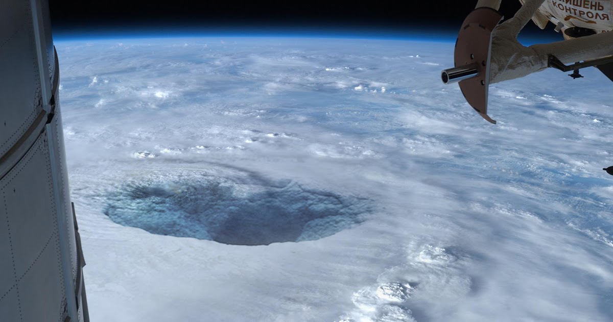
The second image is actually quite impressive. It looks both real and professional, because it is. One would think that if there is any strong photographic proof of an entrance to the Hollow Earth, this image would certainly be it, right? Wrong! Because I live on an island in the Western Pacific Ocean, the minute I saw this image, I had a very strong suspicion that I knew exactly what it is. That is, a close-up view of the eye of a hurricane or typhoon. I spent some time online trying to find a similar image which would tell me more about where it came from, who took it, and when they took it.
After web browsing for a while and coming up empty-handed, I got smart and decided to enlist the help of some of my online friends. So, I posted a message on Facebook, along with just the part of the photograph which only shows the object on the right side. Within barely a few minutes, one of my friends -- an Indonesian girl by the name of Laura -- posted a comment in which she provided me with a website URL that pointed me to a bigger, fuller image, along with a bit of information regarding the origin of the image. The URL was on the NASA website.
As it turns out, contrary to the misguided people who seem to be trying to pass off the above image as an entrance to the Hollow Earth, the photograph is actually a close-up of Super Typhoon Bopha. According to the URL below, the image was taken by Expedition 34 Commander Kevin Ford on Sunday, December 2, 2012 from the International Space Station, as the storm bore down on the Philippines with winds of 135 miles per hour. I don't know if a zoom lens was used or not. But because the photograph shows such a large close-up, for some people it may be difficult to realize that they are actually looking at a dangerous typhoon, and the top of the cloud cover.
In other words, unless one is really familiar with images of typhoons and hurricanes -- as I am -- instead of realizing that he is looking at the tops of the cloud layer, because the image has been posted on a Hollow Earth Theory webpage, he might be deceived into thinking that he is really looking at a vast snow and ice field on the surface of the Earth, and that the great hole in the center is the entrance to the Inner Earth. It just is not so.
As I mentioned earlier, some Hollow Earth proponents can be rather deceptive if it suits their purposes. They so much want to believe in the Hollow Earth, that they will bend the facts, or as in this particular case, provide no facts at all. In short, they will post an image on their Hollow Earth page, without providing any additional information whatsoever about the image, and then let you ASSUME that it is an image of the entrance to the Hollow Earth. Whether or not this is what the Korean blogger was doing, I honestly do not know.
One other interesting point regarding the second image is this: Doesn't it seem rather strange that if this is really a photograph of the surface of the Earth -- which it isn't -- and the "hole" is the entrance to Agharta -- again, which it isn't -- that there is absolutely nothing around it? In other words, if this were truly what Hollow Earth believers claim it is, I would expect to see a certain level of development around it; namely military installations or science stations. Yet there is nothing. Surely if the powers of this world know what this supposed "hole" really is, they would not leave it unguarded, would they? So the claim that this image shows an entrance to the Inner Earth is totally bogus.
In conclusion, what we are seeing in the above photograph in addition to the typhoon itself, is the International Space Station's Permanent Multipurpose Module on the left side of the image, and Mini-Research Module 1 on the right side of the image. You can verify everything I have just stated at the following URL on the NASA website:
https://www.nasa.gov/image-article/super-typhoon-bopha/
I also find the third image to be questionable as well. After looking at it for a few minutes, I realized that this image is supposed to depict the South Pole entrance to the Inner Earth on the continent of Antarctica. In fact, if you look at the brighter white area, it is in the shape of the continent, with lighter white area around it, which I assume is supposed to represent thinner ice shelves that surround the continent. On the bottom of the image you can see the tip of Africa and the island of Madagascar; while on the upper right area you can just barely see the coast of South America.
While the globe part of the image appears to be real, the ice sheet and polar hole are doubtful, in my view. Clearly, they do not look anything like what we see in the NASA and NOAA images. In fact, there is a flaw which is common to all three of these images; namely this: As we discussed before, Hollow Earth adherents claim that a type of mini-Sun floats in the middle of the Inner Earth. Now if we accept the claim that this mini-Sun hovers equidistant from all sides of the Inner Earth, then one would expect that some amount of light would escape via both of the polar holes to the outer atmosphere. Yet strangely enough, in all three of the images which Hollow Earth believers claim are proof of an Inner Earth, we see absolutely no light escaping into the outer atmosphere. In fact, in all three images, the so-called "entrance" is dark in color. So you be the judge. Who are you going to believe?
Of course, I already recognize that regardless of how much sound, scientific evidence I present in this current series which refutes the Hollow Earth Theory, there are always going to be diehard believers who will reject the evidence, and who will continue to cling to their misguided beliefs. No doubt, some of them will make the last-ditch claim that the previous satellite images were doctored/airbrushed by NASA or NOAA in a graphics editing program such as Adobe Photoshop, in order to remove any evidence of the entrances to the Inner Earth. There isn't much that I can do about that. After all, we each choose our own delusions.
Returning to our earlier discussion regarding the South Pole, another development in recent decades which has likewise been perceived by some conspiracy theorists as being part of the overall alleged government-led conspiracy to hide the truth regarding the Inner Earth from the rest of the world, is that on October 4, 1991, an agreement was signed by twenty-four member nations of the Antarctic Treaty. Known as the Protocol on Environmental Protection to the Antarctic Treaty, this agreement entered into force on January 14, 1998, and banned oil and mineral exploration on Antarctica for the next fifty years. Some of the signatories included the United States, the then Soviet Union, Germany, China, Great Britain, France and Canada. In addition to the ban, this agreement included new regulations regarding the protection of wildlife, waste disposal, marine pollution and the continued monitoring of the Antarctic.
While I can obviously understand the level of mistrust that such conspiracy theorists have of national governments -- I don't completely trust governments either -- in my opinion, what obviously invalidates their claim regarding the purpose of the treaty, is the simple fact that there is no verifiable and scientific evidence to even support the existence of the Inner Earth. The entire theory is based on suppositions and personal speculation as well as on very questionable sources. Thus, there is nothing for them to hide, and therefore, no conspiracy. That is to say, at least they are not attempting to conceal the Inner Earth. By the way, the aforementioned treaty is also known as the Antarctic Environmental Protocol, or the Madrid Protocol.
Another piece of purported evidence which has been used by certain Hollow Earth proponents to validate their beliefs in the existence of Agharta -- that is, the Inner Earth -- is the claim that the "Ozone Hole" over Antarctica is located directly above the so-called South Polar opening which leads into the Inner Earth. From the little I have been able to find about this, and if my understanding is correct, their belief seems to be that the hole in the ozone layer results from the Earth's magnetic field, and charged particles from either the Earth itself, or perhaps from the Sun, entering the polar opening. Others claim that the mini-Sun may even have its own magnetic field, and thus emit its own charged particles. Whatever the case may be, they believe that this is what results in the hole in the ozone layer at the South Pole. I will leave it at that.
Some Hollow Earth theorists point to other so-called "unusual signs" in order to prove that something very strange exists at both the extremes of the planet Earth. One of the signs is mammoth tusks which have been continually found on some of the islands that are situated within the Arctic Circle north of Russia. As I looked deeper into this issue, I discovered that for at least the past several hundred years, traders -- or tusk hunters -- have in fact been gathering and selling these tusks. Today, a brisk trade exists between Russia and China for these mammoth tusks. The Chinese carve the tusks into elaborate sculptures and trinkets. A skilled tusk hunter can earn many thousands of dollars in a single week. However, this wealth does come at great personal risk, due to the very dangerous process that is required to mine the tusks.
But you see, some Hollow Earth theorists try to paint a very different picture of this development so that it appears to support their theory. In other words, because more of these frozen mammoth skeletons and tusks continue to be found in these regions, they seem to want us to believe that this is indisputable evidence that live wooly mammoths are roaming out of the polar openings which lead to the Inner Earth, and then dying some time later on the Earth's surface. I recall reading years ago that some of these wooly mammoth remains are so well-preserved, that they still have fresh grass in their frozen mouths.
Of course, in the minds of Hollow Earth theorists, this fact seems to support their belief that the mammoth remains aren't as old as the scientists claim, and that they are relatively recent arrivals from the Inner Earth. Personally, I believe that these carcases are the result of a sudden, catastrophic global flood from thousands of years ago, which we Christians refer to as the Genesis Flood. My belief is that this flood was so sudden, and so complete, that when the Lord eventually caused the waters to recede from the Earth, it quickly froze the remains of many species of animals which existed at the time, when the wind pushed part of the excess water towards the poles, where it froze, forming the great ice shelves that we know today. I am referring to the following Bible verses:
"And God remembered Noah, and every living thing, and all the cattle that was with him in the ark: and GOD MADE A WIND TO PASS OVER THE EARTH, AND THE WATERS ASSWAGED; The fountains also of the deep and the windows of heaven were stopped, and the rain from heaven was restrained; And the waters returned from off the earth continually: and after the end of the hundred and fifty days the waters were abated."
Genesis 8:1-3, KJV
On a side note, if you doubt that this is what those verses are saying, then consider that we are likewise told in the Book of Exodus that the Lord did the very same thing when He divided the Red Sea. God literally used a "strong east wind" to push back the waters of the Red Sea so that the children of Israel could pass through the midst thereof, as can be confirmed by the following verse:
"And Moses stretched out his hand over the sea; and the LORD caused the sea to go back by a strong east wind all that night, and made the sea dry land, and the waters were divided."
Exodus 14:21, KJV
At any rate, in addition to my thoughts regarding the Genesis Flood, as you will now see for yourself, there exists a more mundane explanation for the abundance of the mammoth carcases and tusks which have been discovered in these frozen regions of the world. For example, consider the following excerpt I found which is part of a November 2019 article that appeared in Wired magazine".
----- Begin Quote -----
The frozen land of Siberia is rapidly thawing. Parts of it are warming twice as fast as the rest of the planet. The permafrost -- soil that remains frozen year-round -- is protected by a surface layer of dirt and sediment that thaws in summer and refreezes in winter. But in 2018, some parts of this layer did not freeze at all, leaving the permafrost exposed to even warmer temperatures than usual. For decades, residents of this frozen land, where temperatures regularly dip below minus 30 degrees Celsius, would often stumble upon the remnants of woolly mammoths that died out 10,000 years ago. But as the ground thaws, Siberia is revealing its ancient treasure hoard faster than ever. Now, fuelled by Chinese demand for ivory, tusk hunters are racing to retrieve so-called "ice ivory" from the Siberian permafrost."
----- End Quote -----
So there you have it. Wooly mammoths are not coming from the Inner Earth. They have been dead for thousands of years, and their remains are simply being exposed when the permafrost melts. So whether you believe that the frozen carcases were pushed there by the Genesis Flood and then buried in the mud, or that the wooly mammoths lived and died there the entire time, the point remains that they are being exposed when the permafrost thaws out. In fact, some tusk hunters drill many meters into the permafrost in order to find them. Thus, let me reiterate that the Hollow Earth theorists' belief that living wooly mammoths are wandering from inside the Inner Earth is misguided and totally bogus.
Please go to part four for the continuation of this series.
⇒ Go To The Next Part . . .